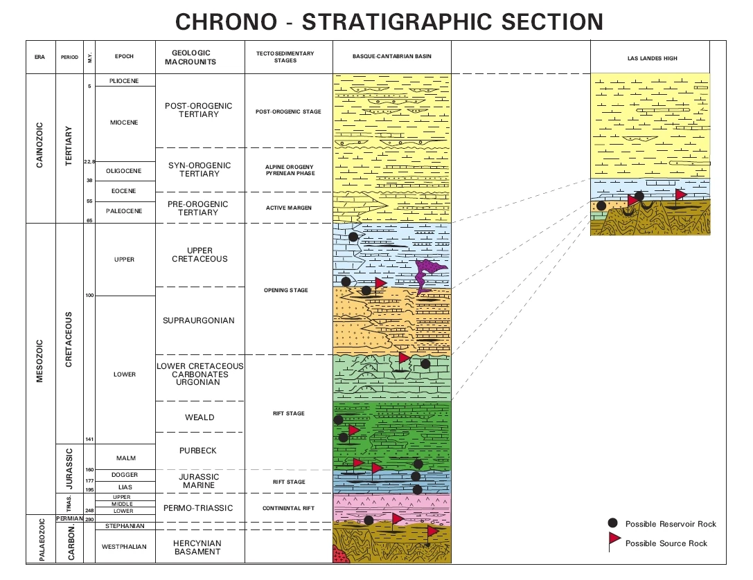
The Basque-Cantabrian Basin is an area of 250 x 100 km located in the extreme west end of the Pyrenees Mountains. It is a Mesozoic and Tertiary sequence on a Hercynian (Devonian-Carboniferous) basement and the stratigraphic colum shows continuous series of sediments from the Permo-Triassic through the Tertiary, reaching a thickness of 15,000 metres, including evaporites, carbonates, clastics and volcanics.
The basin was formed during the stages of rifting and opening of the North Atlantic (Bay of Biscay: separation of the Iberian and European plates) due to deformation due to the collision of the Iberian and European plates from the Maastrichtian through the Oligocene. The Pyrenean phase of the Alpine Orogeny (Eocene-Oligocene) deformed the sedimentary series, uplifted the sedimentary section and inverted the basin.
Geology[]
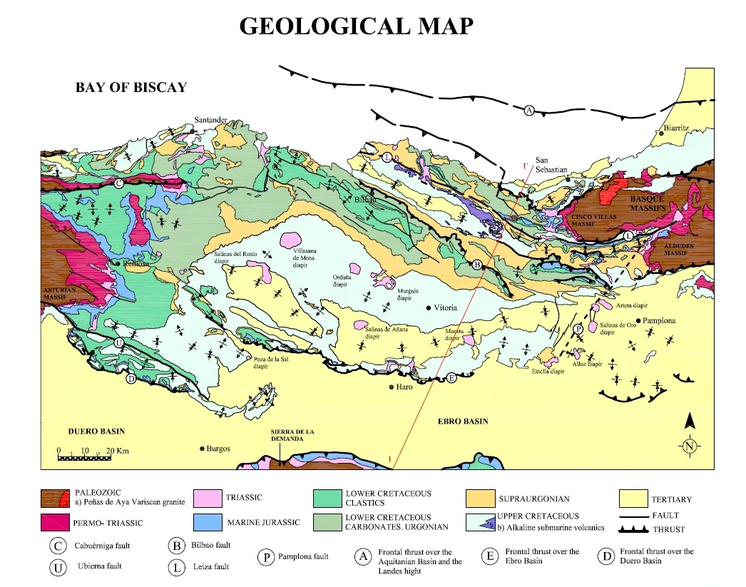
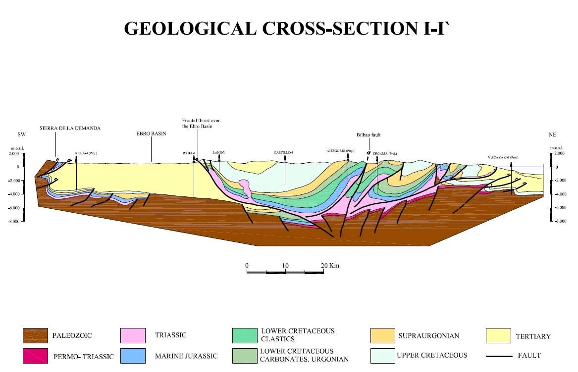
The Basque-Cantabrian Basin is located in the western end of the Pyrenees Mountain Range, surrounded and limited by Paleozoic massifs: Asturian Massif to the west, La Demanda Massif to the south, and Cinco Villas and Quinto Real massifs to the east. This inner plate basin formed during the Triassic related to the beginning of the opening of the North Atlantic and, as a consequence of the opening of the Biscay Bay, was bounded to the northwest and southeast by transform faults. Figure 1 shows the three domains considered by Barnolas and Pujalte (2004) within the basin shown schematically, and which approximately coincide with the North Iberian and European paleomargin segments, especially from the Middle Cretaceous, when these paleomargins were individualized. During the Upper Jurassic and Cretaceous, thick (15000 m) sedimentary piles were deposited with a high sedimentation rate linked to important extensional tectonic subsidence in the basin. These faultcontrolled subsidence was particularly active during the Upper Jurassic-Lower Cretaceous, when the rifting and basin opening processes continued. The stratigraphic record from this period covers three big complexes (Rat, 1959): the Upper Jurassic-Barremian Wealdian Complex at the base (continental siliciclastic sediments); the Aptian-Middle-Upper Albian Urgonian Complex (shelf carbonates with rudists, and basin shales with siliciclastic interbeds); and the Upper Albian-Cenomanian Supra-Urgonian Complex (deep turbidites and fluvial siliciclastic sediments).
The Urgonian Complex reaches a thickness of 4000m of marine sediments. It is limited at the base by siliciclastic formations of saline and fresh water environments, and at the top by a sandy complex. Its most characteristic facies is limestone with rudists, corals and orbitolinids. During the early Aptian (Bedoulian), there was a very significant change in basin paleogeography: the dominant siliciclastic sedimentation shifted to shallow marine sedimentation in a carbonate shelf with rudists, corals and orbitolinids (Gargasian or Upper Aptian), which was interrupted by erosion and episodes of terrigenous input (shale, marl and sandstone) located in depressions between the shelves or relative highs (García Mondéjar, 1990). This set is formed by a group of megacycles or sequences separated by discontinuities, whose synchronism allows to evaluate thickness variations and strong lateral facies changes. This process resulted from strong relative subsidence in relation to structuring of the basin in troughs and relative heights where carbonate shelves developed.
In general terms, the Aptian-Albian interval corresponds to an important rift stage, originated by the movements opening the Bay of Biscay (García-Mondéjar, 1989). This setting helped the rising of mineralizing fluids which metasomatized the Urgonian limestone.
In general terms, the Aptian-Albian interval corresponds to an important rift stage, originated by the movements opening the Bay of Biscay (García-Mondéjar, 1989). This setting helped the rising of mineralizing fluids which metasomatized the Urgonian limestone.
Maps[]
Oil & gas operations[]
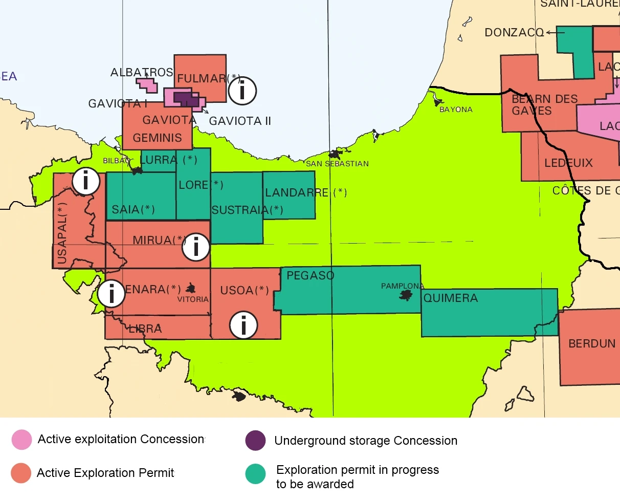
From the early days after independence, the government of Euskadi has promoted the search for hydrocarbons in the Basque-Cantabrian Basin with the intention of reducing its dependence on foreign energy. The good results obtained in neighboring Aquitaine Basin (France) led to the optimism of the authorities at first but as the geology of the basin was investigated and the first prospection wells were drilled at the beginning of the 70, initial optimism was reduced.
Finally, after some small onshore operations the state-owned Petronor began construction of two offshore platforms in the "Gaviota 1" camp in 1982 that were on production until 1994. Later in 1986 Petronor started to build two more offshore platforms in the "Gaviota 2" field. Both camps are located in the sea off Bermeo. In the early 90's Petronor began the construction of 3 new offshore platforms in the field called "Albatros" and are the only ones that remain in production today.
The state owned Petronor is the only company with granted permits to explore and exploit hydrocarbons in the Euskadi's part of the offshore Basque-Cantabrian Basin.
Gaviota 1 & 2[]
Currently out of production they are used as underground gas storage.
Albatros 1[]
It is a gas field is located about 30 kilometers from the coast off Bakio. It is a field of small dimensions in which nine wells are connected to two offshore platforms. There is a pipeline to send the gas directly to the Petronor Gas Plant located in the Petronor Refinery of Muskiz. Today, these two platforms produce about 12% of gas consumed in Euskadi with a combined output of 9.77 millions cu m per day.
At the current rate of production, it is estimated that there are reserves for 6 years but is expected to decline in production within three years.
Fulmar[]
Recently the company Petronor has reported that their works on the research permit "Fulmar" have thrown positive results. The company plans to start building two platforms before the end of 2012. They should start pumping gas in mid-2014 and be fully operational in 2015. Expectations are that these new offshore platforms will replace the Albatros field production and even exceeded it in 30%.
Shale gas operations[]
Oil shale is an organic-rich fine-grained sedimentary rock containing significant amounts of kerogen (a solid mixture of organic chemical compounds) from which technology can extract liquid hydrocarbons (shale oil) and combustible oil shale gas. Shale oil extraction is an industrial process for unconventional oil & gas production. This process converts kerogen in oil shale into shale oil by pyrolysis, hydrogenation or thermal dissolution. The resultant shale oil is used as fuel oil or upgraded to meet refinery feedstock specifications by adding hydrogen and removing sulfur and nitrogen impurities.
In Euskadi there are important oil shale operations in Araba (Enara Camp) and Bizkaia (Balmaseda Camp) both focused in the exploitation of the shales in the Balmaseda Formation.
The companies Fenix Resources and Euskadi Energia have become world leaders in shale gas in-situ production and valorization.
Balmaseda Camp[]
Located in the eskualdea of Bizkaia, Balmaseda Camp was the first shale gas operation in Euskadi. Euskadi Energia has the rights to operate the camp focused in the extration of the gas contained in the shales of the Balmaseda Formation. Due to enviromental concerns Euskadi Energia uses in-situ technologies that perform the processing underground (on-site or in situ processing) by applying heat and extracting the gas via gas wells. Once the gas is extracted is utilized in an IGCC plant located in the shale gas camp. The CO2 and other contaminant gases are injected again to the underground in a virtual Zero-emissions process.
During 2010 the camp produced 2.74 millions cu m of gas per day and there are proven reserves for 20 years.
Enara Camp[]
The field covers a large area around the city of Gasteiz. At present only the south is being exploited by a 50% joint venture between Euskadi Energia and Fenix Resources. The camp is focused in the exploitation of the shales in Balmaseda Formation that reach big thickness in the area. Similar to Balmaseda Camp the operation uses in-situ technologies that perform the processing underground (on-site or in situ processing) by applying heat and extracting the gas via gas wells. Once the gas is extracted is utilized in an IGCC plant located in the shale gas camp. The CO2 and other contaminant gases are injected again to the underground in a virtual Zero-emissions process.
During 2010 the camp produced 3.70 millions cu m of gas per day and there are proven reserves for 20 years while new operations in the camp are being developed.
Current issues[]
- Petronor is preparing the works to build two offshore extraction platforms in the Fulmar Camp. It is expected that the construction will start in the second half of 2012.
- A consortium between Petronor and the californian BNK Petroleum have starting drill in the north half of the Enara Camp. It is expected that they will start producing shale gas at the end of 2013.